
Kreuzberg self-guided walking tour · 90 minutes · map
Kreuzberg on foot: the canal, Kotti, the squats and the East Side Gallery
During the Cold War the Wall closed in Kreuzberg's eastern half on three sides. It became home to guest workers from Turkey, to squatters and to punks. This 90-minute walk goes from a canal-side market through the squares they fought over to the longest surviving stretch of the Wall.
Kreuzberg only became a borough in 1920, and many of its tenements went up from the 1860s. Its eastern part is still called SO 36, after the old postcode for this south-eastern district. After the war, rents were controlled and flats were cheap, so from the late 1960s students, artists and immigrants moved in. Many came from Turkey: West Germany had been recruiting guest workers there and elsewhere since the 1960s. In the 1970s and 1980s SO 36 became the centre of West Berlin's alternative scene and its house squatting. Since reunification it has gentrified a great deal.
A note on accuracy: some stops remember things that have gone, such as murals painted over, and most East Side Gallery paintings are 2009 repaints. We say so where it applies, and every fact links to its source.
- Start
- Schönleinstraße U-Bahn station (U8), on Kottbusser Damm
- Finish
- East Side Gallery visitor centre, Mühlenstraße 73 (the foundation's directions name Warschauer Straße station and bus 300)
- Distance
- 4.2 km, one way
- Time
- About 90 minutes: 56 min walking and 7 stops, plus time to walk the gallery
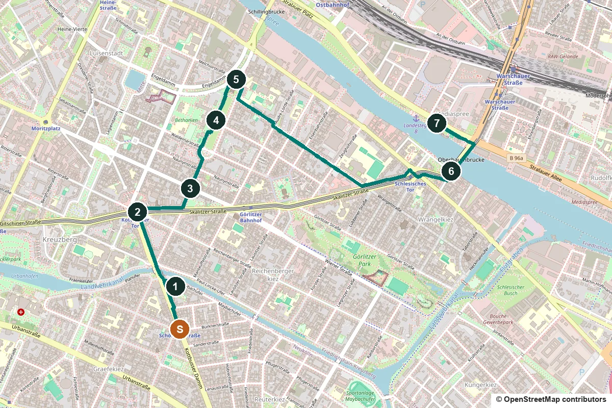
Access, market days and a shorter version ↓
What to see: the stops
-
The Landwehr Canal and the Maybachufer market
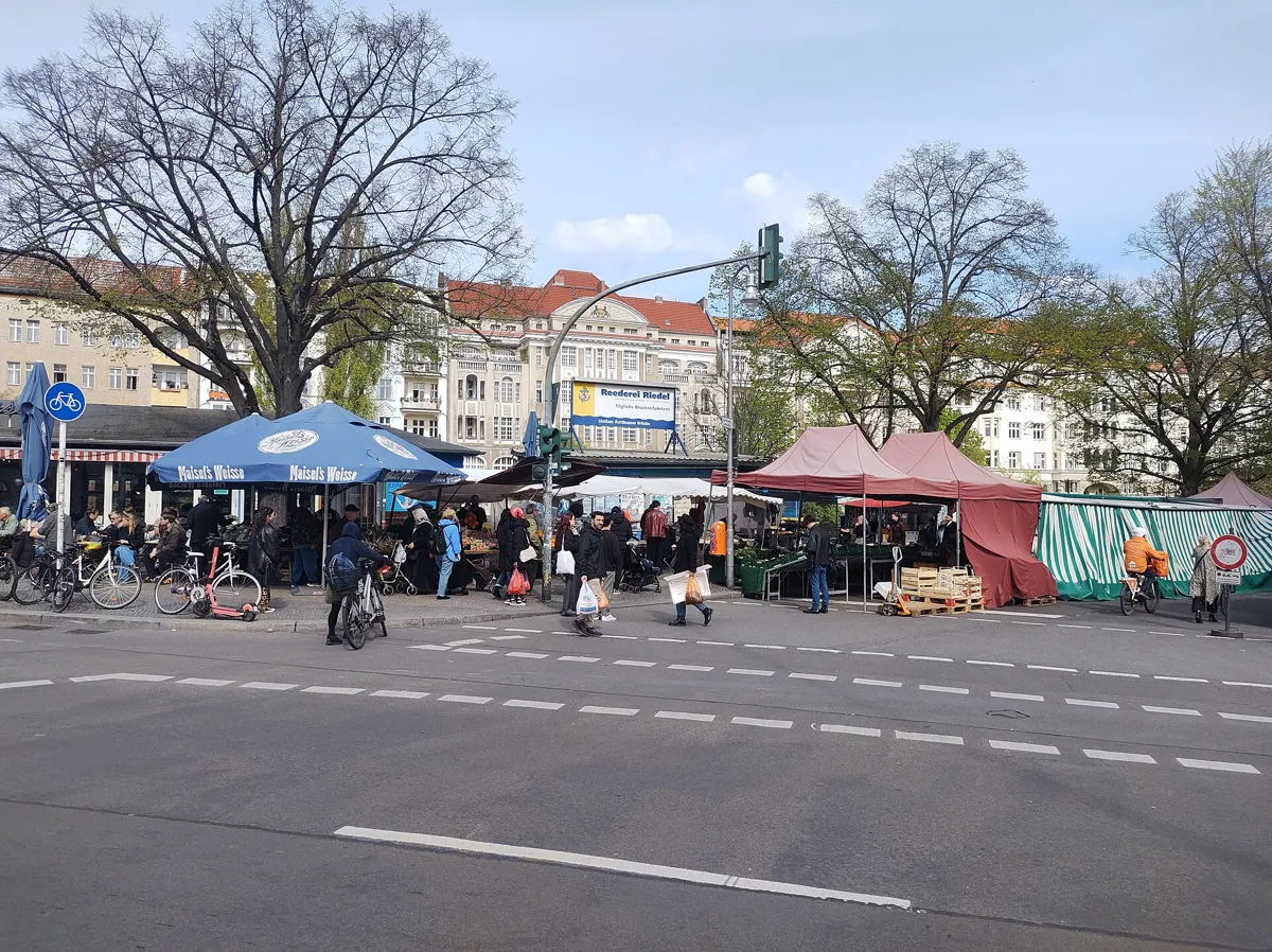
The Tuesday and Friday market on Maybachufer. Photo: Roy Zuo, CC BY-SA 4.0, via Wikimedia Commons (resized). From Schönleinstraße station, walk north up Kottbusser Damm to the canal at the Kottbusser Brücke. The market stalls stand along Maybachufer, the south bank on your right. Maybachufer is in Neukölln; Kreuzberg is across the water. The Landwehr Canal, 10.7 km long, was dug from 1845 to 1850 to plans by the garden designer Peter Joseph Lenné, so that boats could bypass the crowded lock in the city centre. Here, from the Kottbusser Brücke westwards, it follows an older ditch, the Landwehrgraben, dug before 1700 to drain the marshes and turned into a ditch for floating timber in 1705; the bridge stands where an earlier one crossed that ditch. Maybachufer was named in 1882–83 after Albert von Maybach, a lawyer and politician, and a weekly market was already held here then. Today's market, often called the Turkish Market, runs on Tuesdays and Fridays from 11:00 to 18:30, with up to 180 traders; on Saturdays a fabric market takes over from 11:00 to 17:00.
More history
The canal has darker memories further west. In January 1919 the soldiers who murdered Rosa Luxemburg threw her body into it near the Tiergarten; it was found only months later.
Sources: Wikipedia (de), Landwehrkanal; Wikipedia, Landwehr Canal; Wikipedia (de), Maybachufer. Market days: visitBerlin, Türkischer Markt am Maybachufer.
-
Kottbusser Tor, the "Kotti"
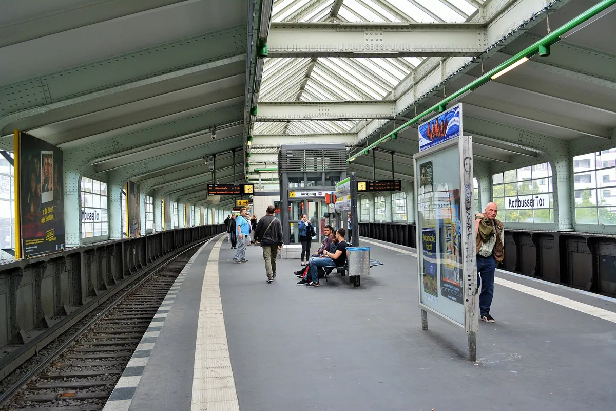
The 1920s platform hall of the elevated station. Photo: Kvikk, CC BY-SA 3.0, via Wikimedia Commons (resized). Cross the Kottbusser Brücke into Kreuzberg and walk straight up Kottbusser Straße to the big roundabout under the elevated railway. Kotti, as Berliners call it, is the centre of SO 36. It takes its name from a gate in the old customs wall that led out towards Cottbus; the wall was pulled down in the 1860s. Trains have crossed the square on the elevated line since 1902, and the underground U8 has stopped here since 1928. The station above you, a long hall of riveted steel and glass resting on very few supports, was built between 1926 and 1929 by Alfred Grenander and Alfred Fehse and is a listed monument. The long slab on the north side, the Neues Kreuzberger Zentrum of 1969–74, straddles Adalbertstraße. It was built to screen off a motorway junction planned at Oranienplatz that was never built. In the late 1970s, plans to clear old housing across SO 36 met the first mass resistance, and Kotti became the symbol of demolition and rebuilding.
More history
On 5 January 1980 Celalettin Kesim was killed here in an attack by Turkish far-right and religious extremists; a memorial stele by Hanefi Yeter was put up at the spot in the early 1990s.
Sources: Landesdenkmalamt Berlin, U-Bahnhof Kottbusser Tor; Wikipedia (de), Kottbusser Tor; Wikipedia (de), U-Bahnhof Kottbusser Tor; Wikipedia (de), Berlin-Kreuzberg.
-
Rio-Reiser-Platz, Oranienstraße and the SO36 club
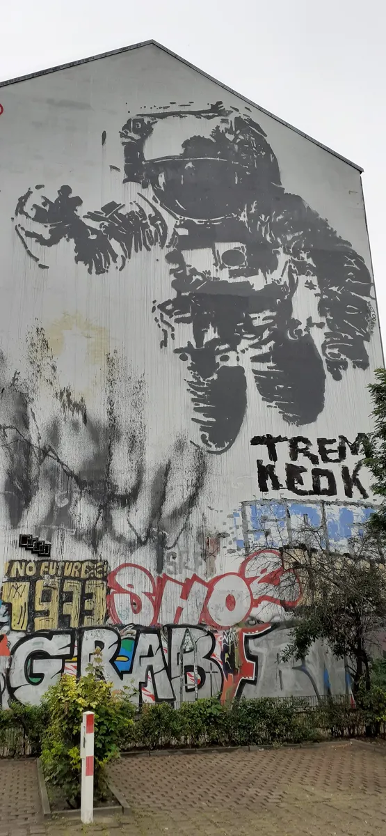
Victor Ash's Astronaut Cosmonaut in 2020. Photo: AlbertRA, CC BY-SA 4.0, via Wikimedia Commons (resized). Walk east along Skalitzer Straße under the railway and turn left into Mariannenstraße. From the corner, look up at the bare side wall of a house ahead: the floating astronaut is Astronaut Cosmonaut, painted by the French artist Victor Ash for the Backjumps street-art festival in 2007. Walk up Mariannenstraße to the square where it crosses Oranienstraße. Named Heinrichplatz in 1849 after a Prussian prince, it was renamed on 21 August 2022 after Rio Reiser (1950–1996), singer of the rock band Ton Steine Scherben, and the band played at the ceremony. The little kiosk of about 1905 is by Alfred Grenander, the Kotti station architect. Oranienstraße, almost 2 km long and named in 1849 after the Dutch House of Orange, is the main shopping street of SO 36, lined with bars and clubs. The SO36 club at number 190, a former cinema, opened as a venue in August 1978 with a "Wall-building festival" mocking the anniversary of 13 August 1961. It became a centre of German punk and new wave; the Dead Kennedys, Die Toten Hosen and Einstürzende Neubauten played here. Since 1997 it has hosted Gayhane, a monthly gay and lesbian party aimed at people with Muslim roots.
More history
In 1981 squatters took over houses on this square to stop them being demolished. In June that year Berlin counted 165 squatted houses, 86 of them in Kreuzberg. After the death of a squatter, Klaus-Jürgen Rattay, Governing Mayor Richard von Weizsäcker sought agreements, and by 1987 sixty squats in West Berlin had been legalised and renovated, including the houses on this square.
Sources: Wikipedia (de), Rio-Reiser-Platz; Wikipedia (de), Oranienstraße; Wikipedia (de), SO36; Wikipedia (de), Blu (for the 2007 festival); Wikipedia (de), Berlin-Kreuzberg.
-
Mariannenplatz, the Bethanien and the Rauch-Haus squat
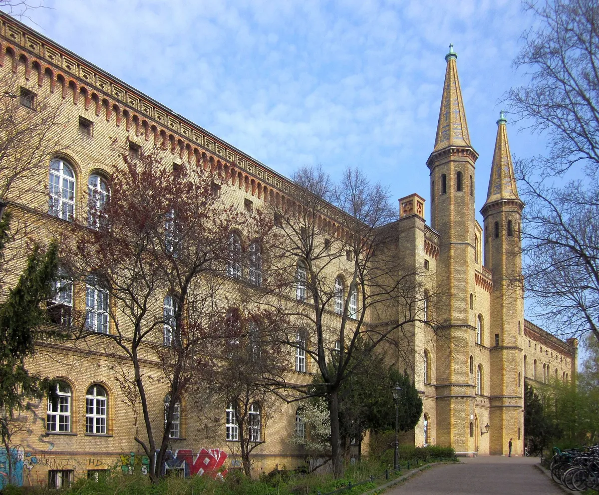
The main building of the former Bethanien hospital. Photo: Jörg Zägel, CC BY-SA 3.0, via Wikimedia Commons (resized). Keep north on Mariannenstraße, across Naunynstraße and Waldemarstraße, into Mariannenplatz. Lenné designed it, and the heritage office dates its first layout to 1853; it is named after Princess Marianne of Prussia. The yellow-brick building with two slender towers on your left is the Bethanien, a hospital and training house for Protestant nursing deaconesses founded by King Friedrich Wilhelm IV. Built in 1845–47, it is one of the oldest surviving hospital buildings in Berlin, and when it opened it stood among gardens and rye fields. Theodor Fontane worked here as a pharmacist in 1848–49, and his pharmacy room survives. The hospital closed in 1970. Local campaigners stopped plans to demolish it, Berlin bought it, and since 1973 it has housed artists' studios and cultural projects. The brick house just to its north is the Georg-von-Rauch-Haus, built in 1893–94 as a home for trainee nurses. In December 1971, after a teach-in with a Ton Steine Scherben concert at the Technical University, young people marched here to occupy the empty hospital. Police cleared the square, but some had barricaded themselves inside. They named the house after Georg von Rauch, an urban guerrilla who had died days earlier in a shoot-out with police. A council official let them stay, and about 40 people still run it themselves.
More history
On 19 April 1972 about 400 police raided the Rauch-Haus. Ton Steine Scherben sang about it in the Rauch-Haus-Song (1972), which names Mariannenplatz.
Sources: Landesdenkmalamt Berlin, Bethanien; Landesdenkmalamt Berlin, Mariannenplatz; Wikipedia (de), Bethanien; Wikipedia (de), Georg-von-Rauch-Haus; Wikipedia (de), Mariannenplatz.
-
St Thomas church and the Tree House on the Wall
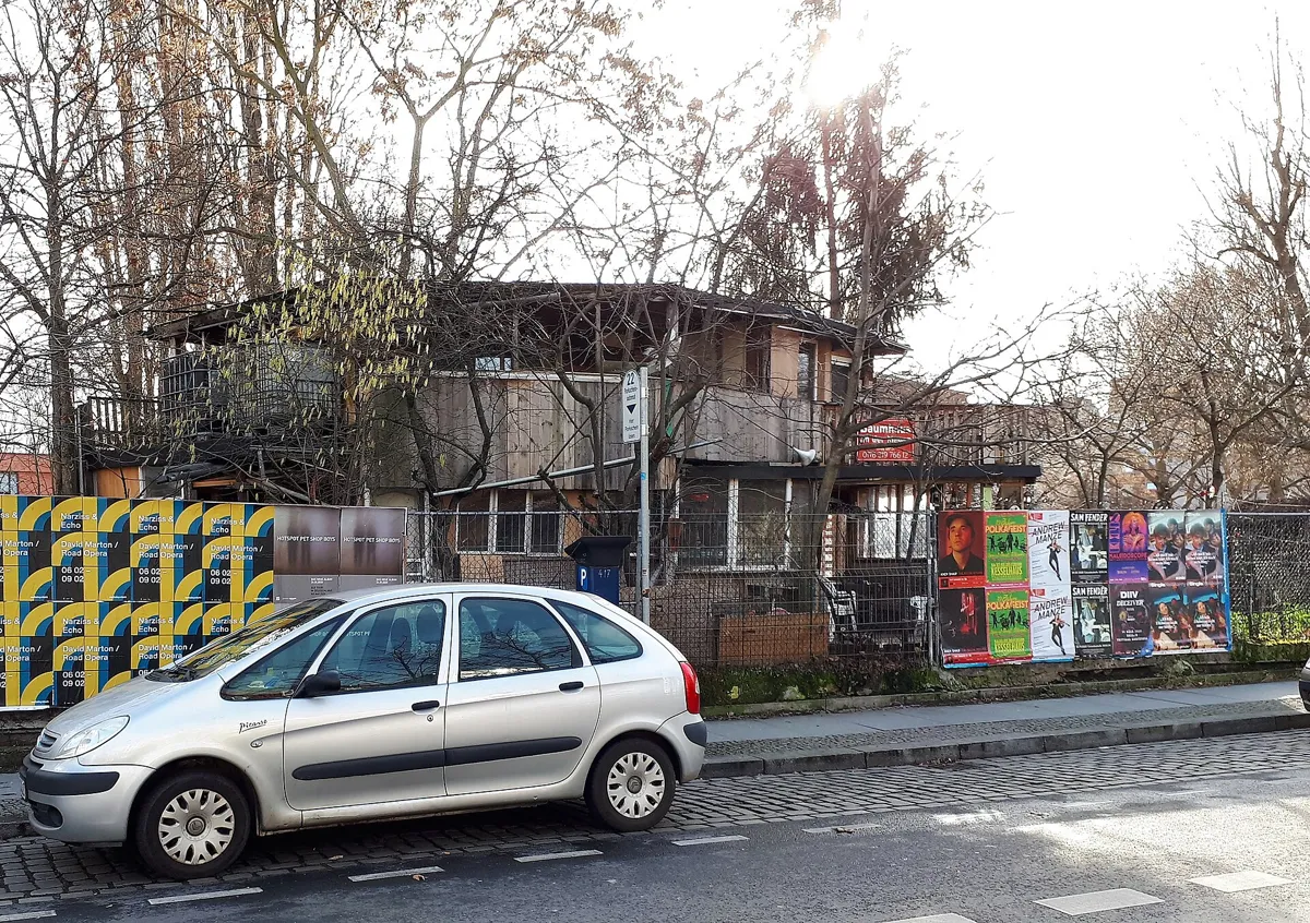
Osman Kalın's house on Bethaniendamm. Photo: Fridolin freudenfett, CC BY-SA 4.0, via Wikimedia Commons (resized). Walk north along the west side of the square, past the Rauch-Haus, to Bethaniendamm. The Wall ran along this street. The big domed church on your right is St Thomas, designed by Friedrich Adler for 3,000 worshippers and opened in 1869. The Wall split its parish in 1961 and left it on the edge of West Berlin, and in the 1980s the parish played an active part in the squatting movement. Opposite, among the trees, stands a hut known as the Tree House on the Wall, though it is really a garden house built around two trees. Osman Kalın (1925–2018) left Yozgat in central Anatolia in 1963, worked in Austria, Stuttgart and Mannheim, and came to Berlin in 1980. In 1983, as a pensioner, he began clearing rubbish from a small triangle of land here. It belonged to East Berlin but lay on the western side of the Wall, so neither side looked after it. He grew vegetables and built a one-storey hut: GDR border guards forbade anything taller than the Wall, suspecting he might dig an escape tunnel. After 1989 he added a second floor and gave it a made-up address, Bethaniendamm 0. Arsonists burned it in 1991 and 2003; each time it was rebuilt. It is private: look from the pavement.
More history
In the 1990s the Mitte district told Kalın to leave the land. He refused, backed by neighbours, the Kreuzberg council and the pastor of St Thomas. His son Mehmet now looks after the house.
Sources: Wikipedia (de), Baumhaus an der Mauer; Landesdenkmalamt Berlin, St.-Thomas-Kirche; Wikipedia (de), St.-Thomas-Kirche.
-
The Oberbaum Bridge and Blu's lost murals
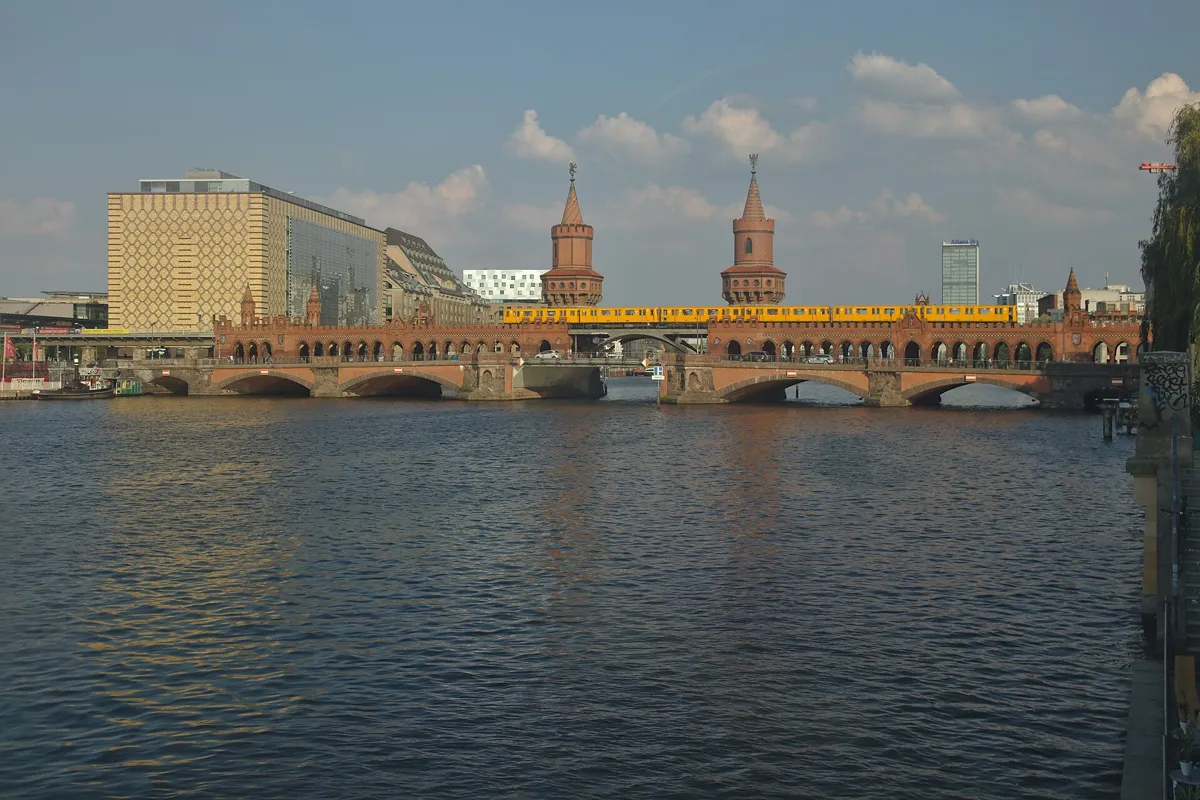
The bridge from May-Ayim-Ufer on the Kreuzberg bank. Photo: Paul Korecky, CC BY-SA 2.0, via Wikimedia Commons (resized). Walk back to Mariannenplatz and follow Wrangelstraße south-east. At Skalitzer Straße turn left and follow it to Schlesisches Tor, then keep on along Oberbaumstraße to the foot of the bridge, where Falckensteinstraße comes in. The blocks south of Skalitzer Straße, down to the canal, are the Wrangelkiez, where Kreuzberg's Turkish community is most concentrated. Since 2001 this bridge has been the only direct link between the two halves of the borough of Friedrichshain-Kreuzberg. Otto Stahn designed it as a mock-medieval city gate, with towers modelled on one in Prenzlau, and it was finished in 1896; Berlin's first U-Bahn line has run along its upper deck since 1902. On 23 April 1945 German troops blew up most of its central arch. In the divided city it was a border crossing, closed to everyone when the Wall went up, and open to pedestrians permanently from 1972. Its new centre section, by Santiago Calatrava, was finished in 1995. The building at the end of Falckensteinstraße used to carry the Italian artist Blu's Leviathan of 2007, a giant made of hundreds of small pink bodies; it was covered during building work in 2024. About 150 m south-east along Schlesische Straße, at the end of Cuvrystraße, two more Blu murals from 2007–08 faced an empty plot. On the night of 11–12 December 2014 they were painted black, with Blu's agreement, as a protest against the city's development policy. Two long new buildings, the Neue Spreespeicher, now stand on the plot.
More history
Here the whole river belonged to East Berlin, and West Berlin began at the Kreuzberg bank. Between 1972 and 1975 four children, among them Cengaver Katranci and Cetin Mert, fell in while playing on that bank and drowned: West Berlin rescuers could not enter East Berlin's water, and GDR boats did not come. Only in October 1975 did the two sides agree on rescues, and an emergency call point was put up at the south end of the bridge.
Sources: Landesdenkmalamt Berlin, Oberbaumbrücke; Wikipedia (de), Oberbaumbrücke; Wikipedia, Kreuzberg; Wikipedia (de), Cuvry-Graffiti; Wikipedia (de), Cuvrybrache; Wikipedia (de), Blu; Berlin Wall Foundation, the Wall on Mühlenstrasse.
-
The East Side Gallery, the longest surviving stretch of the Wall
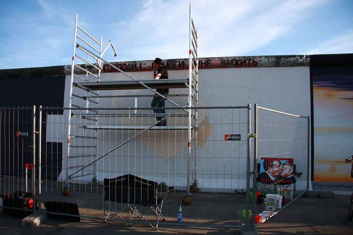
Dmitri Vrubel repainting his mural on the cleaned wall. Photo: Wo st 01, CC BY-SA 3.0 DE, via Wikimedia Commons (resized). Cross the bridge on the walkway under the railway arches, then turn left along Mühlenstraße. The painted wall runs on your left, and the visitor centre, in an old border gatehouse, is at number 73. The Berlin Wall Foundation calls this the longest remaining section of the Wall: 1.3 km between the Oberbaum Bridge and Ostbahnhof. It was not the outer wall. The border here was the Kreuzberg bank, so this is the inner wall that closed off the death strip from East Berlin. Because Mühlenstraße was a "protocol route" for high-ranking visitors to the GDR, this inner wall resembled Border Wall 75, the 3.5-metre type that usually faced West Berlin. In 1990, 118 artists from 21 countries painted more than a hundred pictures on it, and the gallery opened on 28 September 1990. It became a listed monument in November 1991. What you see is mostly not from 1990: in the restoration of 2008–09 most paintings were blasted off to repair the concrete, and the artists were invited back to repaint them. A few refused, so some segments are blank. Only Hands, by Margaret Hunter and Peter Russell, is the 1990 original. Further along, look for Dmitri Vrubel's kiss, My God, help me to survive this deadly love, painted after a photograph by Régis Bossu.
More history
At least five people died in the Spree between here and the Schilling Bridge trying to escape, the first, Udo Düllick, on 5 October 1961. Since 2018 the Berlin Wall Foundation has looked after the site.
Sources: Berlin Wall Foundation, the open-air gallery; Berlin Wall Foundation, the Wall on Mühlenstrasse; Landesdenkmalamt Berlin, East Side Gallery; Wikipedia (de), East Side Gallery; Wikipedia, East Side Gallery. Visiting: Berlin Wall Foundation, information for your visit.


Practical details
- Terrain
- Flat city streets and a canal path.
- Water
- Three drinking-water points are mapped near the route: Kottbusser Tor (53 m), Rio-Reiser-Platz (106 m), and Mariannenplatz (39 m), the last with limited wheelchair access.
- Toilets
- Toilets are mapped: near Landwehr Canal market (148 m, fee, wheelchair), Kottbusser Tor (27 m, free, no wheelchair), Mariannenplatz (64 m and 87 m, both free with wheelchair access), Oberbaum Bridge (108 m, free, wheelchair), and East Side Gallery (220 m, free, wheelchair).
- Step-free
- The Berlin Wall Foundation says the East Side Gallery is suitable for wheelchairs and that there are restrooms there. Steps are mapped near the route at Schönleinstraße (20), Landwehr Canal (24), Kottbusser Tor, Mariannenplatz, and Oberbaum Bridge (7).
- Sit and eat
- The market on Maybachufer (stop 1) has food stalls on market days, and Oranienstraße (stop 3) is lined with cafés, bars and snack bars. Mariannenplatz (stop 4) has lawns and benches.
- When to go
- The Maybachufer market runs on Tuesdays and Fridays, 11:00 to 18:30, and the fabric market on Saturdays, 11:00 to 17:00. The East Side Gallery is open around the clock and free; its visitor centre opens daily, 10:00 to 17:00, and is closed from 24 December 2026 to 2 January 2027.
- Shorter walk
- Stop after stop 5, the St Thomas church and the Tree House (2.1 km), and walk back south down Mariannenstraße to Kottbusser Tor, where the U1 and U8 stop.
- Getting back
- For the East Side Gallery, the Berlin Wall Foundation lists Warschauer Straße S- and U-Bahn station (S3, S5, S7, S9, S75, U1, U3), trams M10 and M13, and buses 300 and 347.
Walking distances and times from the OSRM foot router on OpenStreetMap data. Market days from visitBerlin; East Side Gallery hours, access and transport from the Berlin Wall Foundation. Steps, fountains and toilets from OpenStreetMap. Checked 5 October 2026.
Questions people ask
How long does a Kreuzberg self-guided walking tour take, and is there a map?
About 90 minutes: 4.2 km, 56 minutes of walking and seven stops, from Schönleinstraße U-Bahn station to the East Side Gallery visitor centre on Mühlenstraße. The map is on this page, and you can print it or save it as a PDF.
What is Kreuzberg known for?
Its eastern half, SO 36, was hemmed in by the Wall on three sides and became famous in the 1970s and 1980s for squatters, punk and an alternative scene. Many residents have Turkish roots, a community that grew after West Germany recruited guest workers from the 1960s. Since 1990 the area has gentrified, but it is still known for its nightlife and arts scene.
Is the East Side Gallery free?
Yes. The Berlin Wall Foundation says admission is free and the gallery is open around the clock. Its visitor centre at Mühlenstraße 73 opens daily from 10:00 to 17:00 and is the meeting point for paid guided tours. Check the foundation's site before you go.
Where can you see street art in Kreuzberg?
On this walk: Victor Ash's astronaut from 2007, seen from the corner of Mariannenstraße and Skalitzer Straße, and the East Side Gallery across the Oberbaum Bridge. Some of Berlin's best-known murals, by the Italian artist Blu near the bridge, are gone: two were painted black in December 2014 and the third was covered in 2024.
Is Kreuzberg safe to walk around?
The walk follows busy streets and squares. Berlin police classify Kottbusser Tor as a "crime-burdened place" (kriminalitätsbelasteter Ort). Police figures for May to December 2021 show mostly assaults, thefts and drug offences around the square, and a police post opened above it in February 2023. Keep an eye on your bag there, as in any busy transport hub.
Walk it with Strolio
Open Strolio at Kottbusser Tor and ask for 90 minutes through Kreuzberg to the East Side Gallery. Strolio builds walks in any city with mapped streets, so its route may pick different stops from this page. Stories play as you reach each place, and you can ask about anything else you pass, by voice or with a photo. You can also start from your hotel and choose your own time and interests.
More walks in Berlin
- Along the Wall: ~1½ h, 8 stops. Follow the Berlin Wall's line from the Reichstag and Brandenburg Gate to Checkpoint Charlie, past the last pieces still standing.
- Unter den Linden and Museum Island: ~75 min, 8 stops. Prussian Berlin from the Gendarmenmarkt and the 1933 book-burning site to the cathedral, the rebuilt palace and the Nikolaiviertel.
- All Berlin walks, with maps side by side.
- Walks in other cities.
Sources
- Landesdenkmalamt Berlin, Denkmaldatenbank: U-Bahnhof Kottbusser Tor, Diakonissenkrankenhaus Bethanien, Mariannenplatz, St.-Thomas-Kirche, Oberbaumbrücke, East Side Gallery. We used their facts and wrote our own text.
- Berlin Wall Foundation (Stiftung Berliner Mauer): The world's longest open-air gallery, The Berlin Wall on Mühlenstrasse, Information for your visit
- visitBerlin: Türkischer Markt am Maybachufer
- Wikipedia (German): Berlin-Kreuzberg, Landwehrkanal, Maybachufer, Kottbusser Tor, U-Bahnhof Kottbusser Tor, Rio-Reiser-Platz, Oranienstraße, SO36, Mariannenplatz, Bethanien, Georg-von-Rauch-Haus, Baumhaus an der Mauer, St.-Thomas-Kirche, Wrangelkiez, Oberbaumbrücke, Blu, Cuvry-Graffiti, Cuvrybrache, East Side Gallery
- Wikipedia (English): Kreuzberg, Landwehr Canal, East Side Gallery
- Map data and places: © OpenStreetMap contributors, ODbL; walking route from the OSRM foot router run by FOSSGIS
- Photos: Wikimedia Commons contributors Roy Zuo, Kvikk, AlbertRA, Jörg Zägel, Fridolin freudenfett, Paul Korecky and Wo st 01, credited under each photo